


Due to the present severe road conditions and the winter storm warning that is predicting continued freezing rain and snow, all schools in Box Elder School District will be closed on Monday, January 9th. School will resume on Tuesday. Please stay safe and warm!
===========================================================
*****From Box Elder County Emergency Management*****The Box Elder Emergency Management is sending out an automated phone message regarding our current weather situation. Here is more detail.
You may be directed to this message from a CODE RED Phone call may have received, or may still receive in the next while, IF you still have a land line phone or IF you have registered your cell phone with CODE RED.
WINTER STORM CONCERNS
This unique winter storm brings several issues we need to be aware of. It is already snowing again. As it turns from snow to rain over the next 24 hours we may see any of the following:
* Freezing rain is caused when rain falls to a colder frozen environment at ground level. This will create very slippery walking and driving surfaces. AND it could do significant damage to trees and power lines.
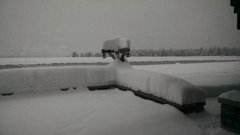
* Increased snow load on roofs as the snow absorbs the rain and increases in weight per square foot. Flatter roofs are more vulnerable than steeper roofs. Older homes may be more vulnerable than newer homes. Confer with a professional about your situation. (more info in a previous post)
* Dams of snow, ice and other debris in culverts, storm drains and bridges can be a real problem. Remove these obstructions only if you can do so safely, otherwise contact your community public works department or the Box Elder Public Saafety Dispatch center.
* Frozen ground will not absorb any of the rain or melted snow and ice. As it encounters snow and ice piles it will pool and run in very unpredictable ways, and can cause flooding in areas which are not traditionally impacted.
* Areas which historically are prone to flooding, creeks and rivers could be significantly impacted by this type of storm.
* Debris flows are created when significant water flows can dislodge rocks, trees and other debris from hills and mountains. Debris flows can travel for long distances.
Be vigilant and aware of your circumstances, whether at home, work or in your car, over the next several days. If you need information on resources, or other assistance, contact your city / town emergency manager or elected officials. For those in the unincorporated areas of the county you will rely directly on county services.
******"Heads-Up" report from the National Weather Service****** FLOOD WARNING
• Sunday will warm up to 40 degrees
• Rain will begin Sunday through Monday
• Areas of concern: Little Bear (and the confluence of the Bear River), Weber Valley rivers. Areas below 5500 feet. Weber County, Cache County, Box Elder County....
• Likely see 1 inch of rain in a 12 hour period (rain on snowmelt)
• Monday at 3:00 p.m. is the time when rivers will increase and possible flooding could occur
• Concern with increase of flows of rivers and public safety around rivers. Rivers will increase quickly during this 12 hour period.
• Concern with possibly flooding of basements (areas that have flooded in the past could be flooded again, especially in Ogden area)
• Concern with culverts and bridges if debris is already in the way.
• A Flood Advisory will be sent out Saturday and a possible Flood Warning on Sunday.
• No media has been contacted yet, Brian is making personal phone calls to emergency managers.
• DEM recommends sandbag preparation, culvert cleaning, staffing preparation.
• SERT team will be notified with an email. No actions required, this is a "heads up" email of potential flooding. A webEOC Event will be created
• DEM will increase the EOC activation to Level 3 Monitoring starting Friday at 0800 hrs through the incident period. No personnel will be staffing the EOC over the weekend, however Bob Carey is the Staff Duty Officer for the weekend, his cell number is 801-554-5957.